

Converting point clouds to CAD drawings is one of the biggest bottlenecks in modern surveying and architecture. Teams capture millions of 3D data points in the field, only to spend days or even weeks redrawing them into usable 2D floor plans, elevations, or sections. Manual tracing drains valuable staff hours, outsourcing is expensive and unreliable, and projects often stall while everyone waits for clean DWG deliverables.
This guide explains what point cloud to CAD conversion is, why it matters, and how to streamline the workflow. You will learn about the main challenges, the different scan to CAD workflows available, and the tools surveyors are using today to cut drafting time by up to 60%. By the end, you will know exactly how to move from raw scan data to professional CAD drawings faster, cheaper, and with consistent accuracy.
What Is Point Cloud to CAD Conversion?
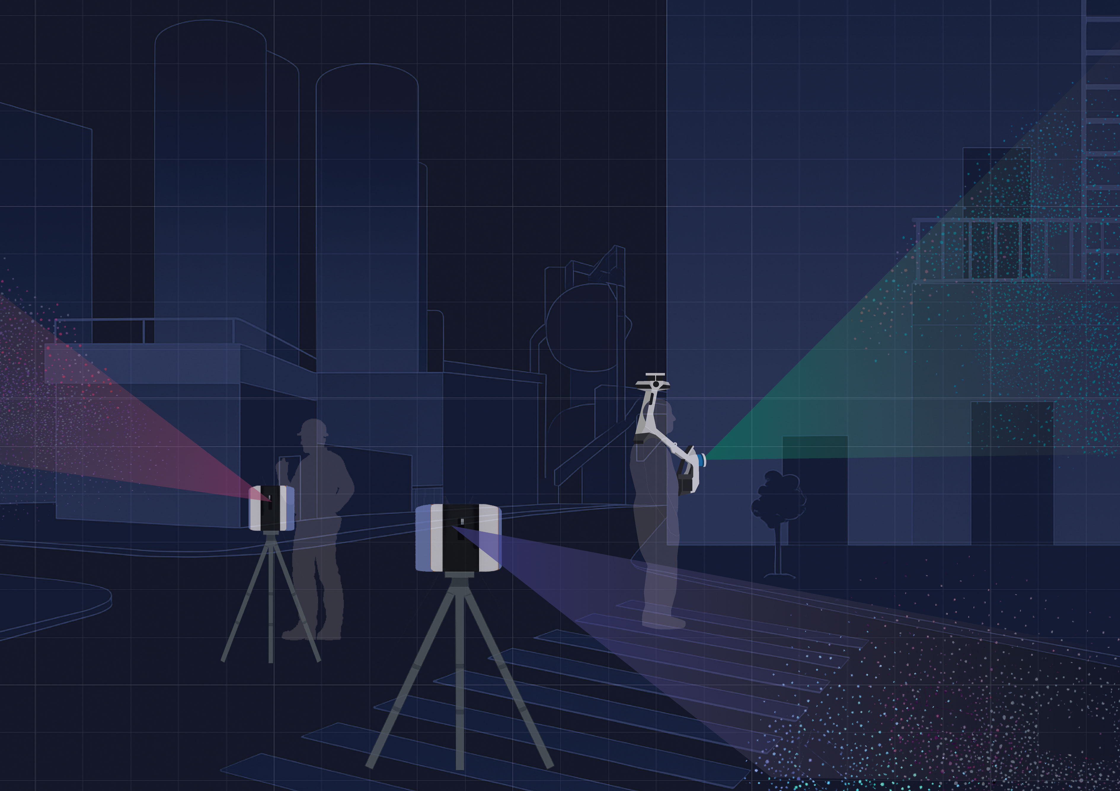
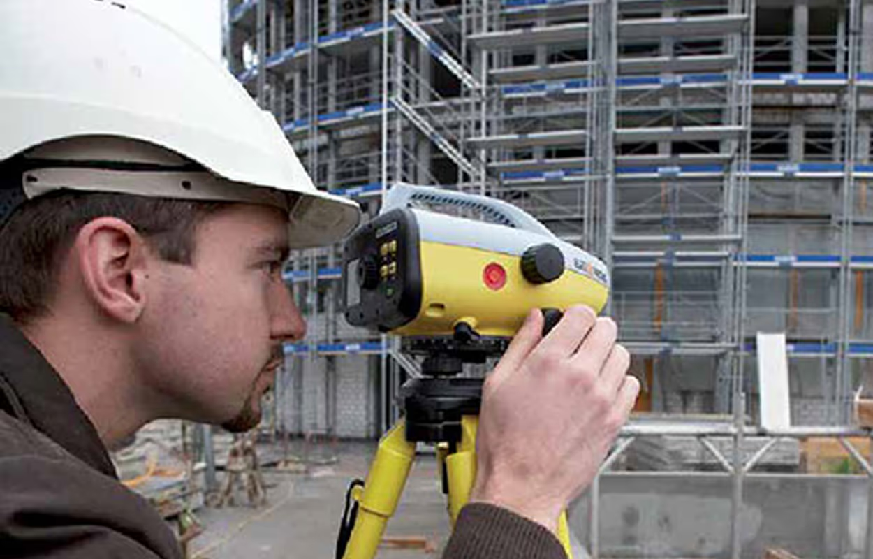
A point cloud is a dataset of millions of points captured by 3D laser scanners or LiDAR devices. Each point has X, Y, and Z coordinates that represent the surfaces of a building, site, or object. Common formats include E57 and FLS, which store raw scan data from popular scanners.
While point clouds are incredibly detailed, they are not practical for architects, engineers, or contractors. Most clients require CAD drawings in DWG format, because DWGs are clear, editable, and standardized across the industry. A project might need:
- 2D floor plans for architects
- Elevations and sections for engineers
- As-built drawings for contractors or facility managers
Point cloud to CAD conversion is the process of turning raw 3D scan data into these usable CAD deliverables. Instead of overwhelming teams with millions of points, the workflow reduces the dataset into clean linework, layers, and blocks that follow established CAD standards. Modern point cloud software makes this process faster and more consistent, and with the rise of AI point cloud to CAD tools, many survey teams are now automating the most time-consuming steps.
Why Point Cloud to CAD Matters for Surveyors and CAD Teams
Point clouds are powerful datasets, but they are not practical deliverables on their own. A raw scan may contain millions of points, which is useful for capturing site detail but overwhelming for architects, engineers, or contractors who need clear drawings to work from. Converting these scans into CAD drafting from scans ensures the data becomes usable, standardized, and easy to edit.
For surveyors, the ability to deliver accurate DWG files quickly is directly tied to profitability. Clients expect point cloud to drawing outputs such as floor plans, elevations, and sections, not raw scan files. If teams rely on manual tracing or outsourcing, projects stall, deadlines slip, and costs increase. By contrast, firms that invest in streamlined scan to CAD workflow methods see faster turnaround, fewer revisions, and happier clients.
The impact is not only about efficiency. Accurate CAD drawings reduce the risk of errors downstream in construction or renovation. A contractor who receives clean linework aligned to industry standards can build with confidence, while a design team can focus on higher-value work instead of correcting messy data. In this way, point cloud to CAD conversion is more than a technical task. It is a cornerstone of delivering professional, reliable results across the entire project lifecycle.
The Challenges of Manual and Outsourced Conversion
For many teams, the traditional way of creating CAD drawings from point clouds is to trace scans by hand. This approach gives surveyors full control, but it also creates some of the biggest bottlenecks in modern projects. Manual conversion is extremely slow, requires highly skilled staff, and often leads to inconsistent results.
The main drawbacks of manual conversion include:
- Days or even weeks spent redrawing scans into 2D CAD drawings
- Inconsistent accuracy when small details are missed
- Senior staff tied up with low-value drafting instead of leading projects
- Limited scalability as project sizes grow
Outsourcing is the alternative many firms turn to, but it comes with its own risks. External vendors may deliver drawings that do not match your internal CAD standards, which creates extra revisions and delays. Quality control is difficult when drawings are produced off-site, and outsourcing costs can eat heavily into project margins.
Common outsourcing issues include:
- Drawings that do not follow company CAD templates or standards
- Delays caused by back-and-forth corrections
- Loss of control over accuracy and consistency
- Higher costs that reduce project profitability
Both manual conversion and outsourcing share the same limitation: they do not scale. As projects grow larger and deadlines get tighter, survey firms need a more reliable point cloud to CAD workflow that reduces repetitive tracing and avoids dependence on external teams. This is where dedicated point cloud software becomes critical, offering automation and consistency that manual methods cannot match.
Scan-to-CAD Workflows Compared
When it comes to producing CAD drawings from point clouds, survey teams usually choose between three approaches: manual tracing, outsourcing, or dedicated software. Each method has different trade-offs in terms of speed, accuracy, and cost. Understanding these differences is key to selecting the right scan to CAD workflow for your team.
Manual Conversion
Manual conversion means redrawing walls, doors, and measurements directly from the scan.
- ✅ Full control over every line and detail
- ❌ Extremely slow, often taking days per drawing
- ❌ Accuracy depends on the individual drafter
- ❌ Senior staff time wasted on low-value work
Outsourcing
Outsourcing gives the task to an external team or service provider.
- ✅ Faster delivery compared to manual work
- ✅ Frees up internal staff
- ❌ Higher cost per project
- ❌ Inconsistent results and extra revisions
- ❌ Limited control over quality and CAD standards
Dedicated Software
Specialized point cloud software is designed to automate much of the process and integrate directly with CAD tools.
- ✅ Delivers consistent accuracy
- ✅ Works inside AutoCAD, BricsCAD, or ZWCAD
- ✅ Up to 60 percent faster drafting compared to manual methods
- ✅ Scales across multiple projects and teams
- ❌ Requires training and adoption of new tools
A well-structured scan to CAD workflow is the difference between projects that run smoothly and projects that get stuck in bottlenecks. Most modern survey teams are moving toward software-driven methods because they combine the control of in-house drafting with the efficiency of automation.
How to Convert Point Clouds to DWG (Step by Step)
There are several ways to turn raw point clouds into usable CAD drawings. The workflow you follow depends on the method you choose: manual drafting, outsourcing, or using dedicated point cloud to CAD software.
1. Manual Tracing
The most traditional method is to trace features from the scan by hand.
- Open the scan in a point cloud viewer or processing tool (such as ReCap or CloudCompare).
- Export views, sections, or slices from the point cloud.
- Redraw walls, doors, and features manually in AutoCAD or another CAD tool.
This method gives you control but is painfully slow and error-prone. Even a small floor plan can take days to complete.
2. Outsourcing to a Service Provider
Some firms outsource the conversion to drafting companies that specialize in scan-to-CAD.
- You send them your E57 or FLS files.
- They process and redraw the scans into DWG deliverables.
- You receive finished 2D drawings after several days or weeks.
This saves internal time but often leads to inconsistent results that do not follow your CAD standards. Outsourcing also adds significant costs to projects.
3. Using Dedicated Software (Recommended)
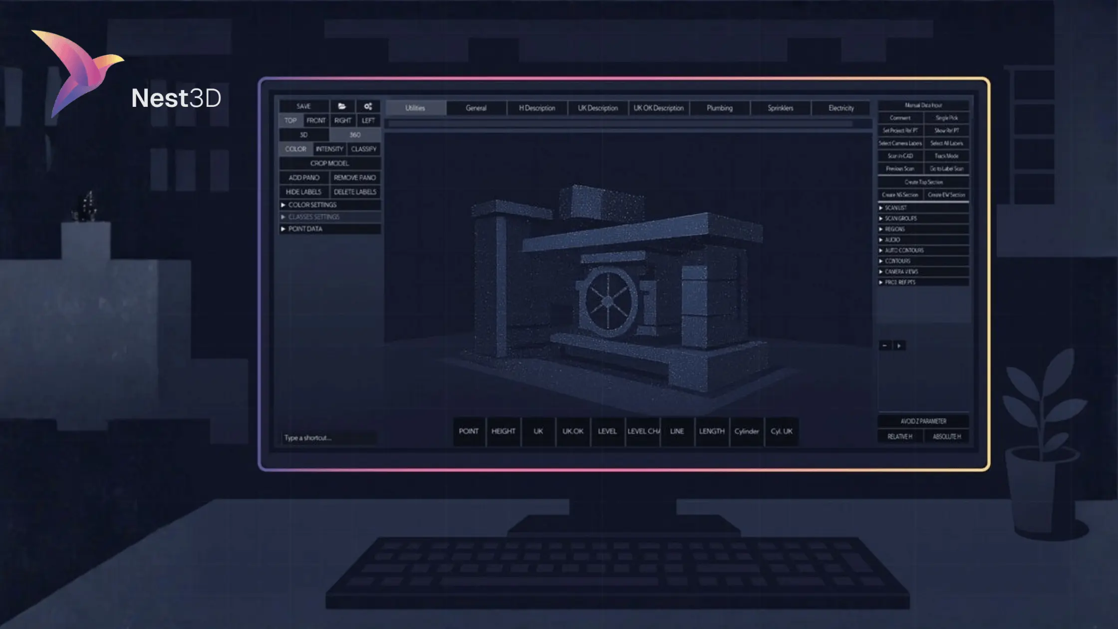
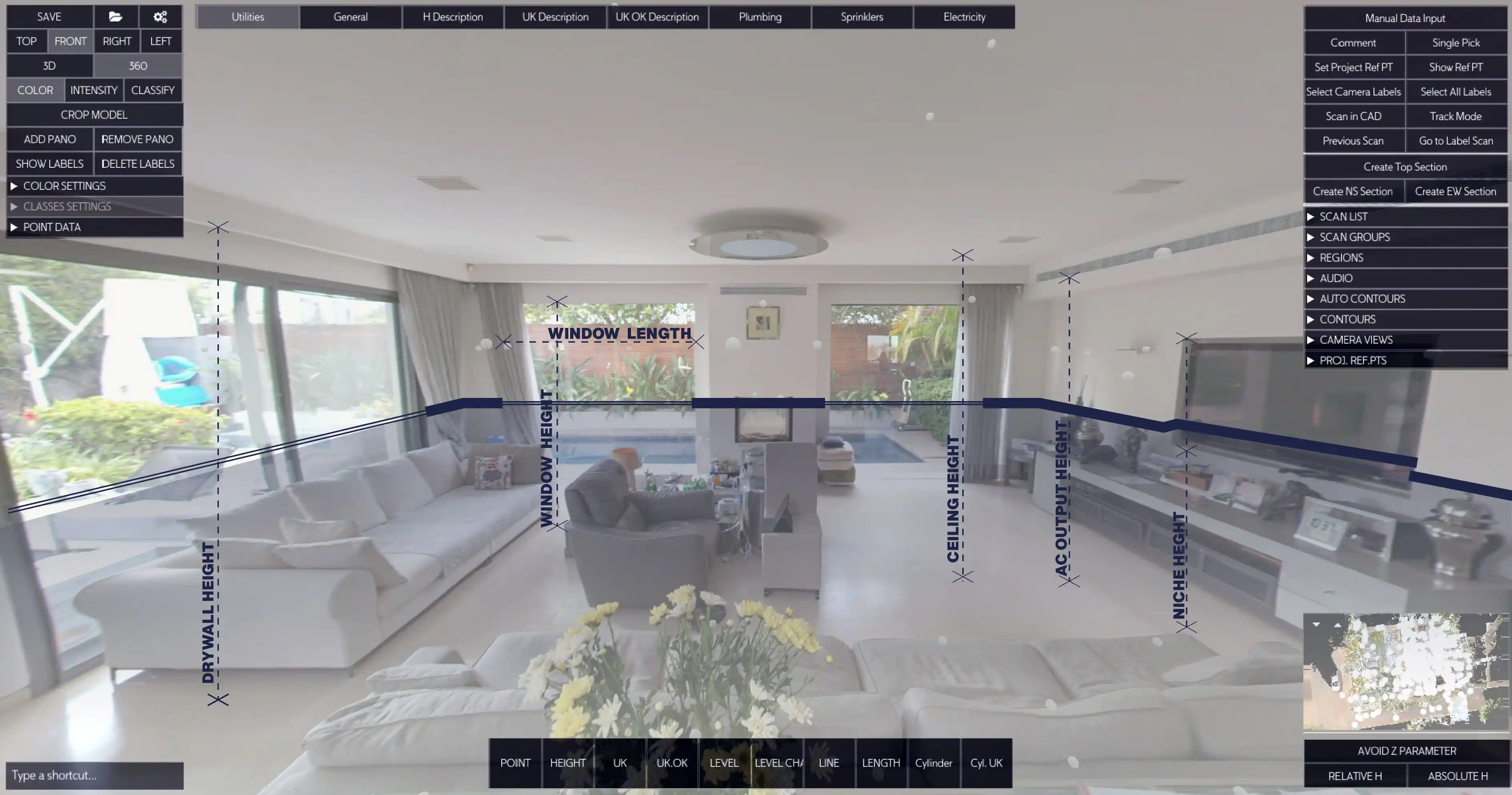
Modern point cloud software automates much of the process and works directly inside CAD tools. With solutions like Nest3D, the workflow looks like this:
1. Import your scans (E57 or FLS).

2. Apply your company’s DWG template with layers, linetypes, and blocks.
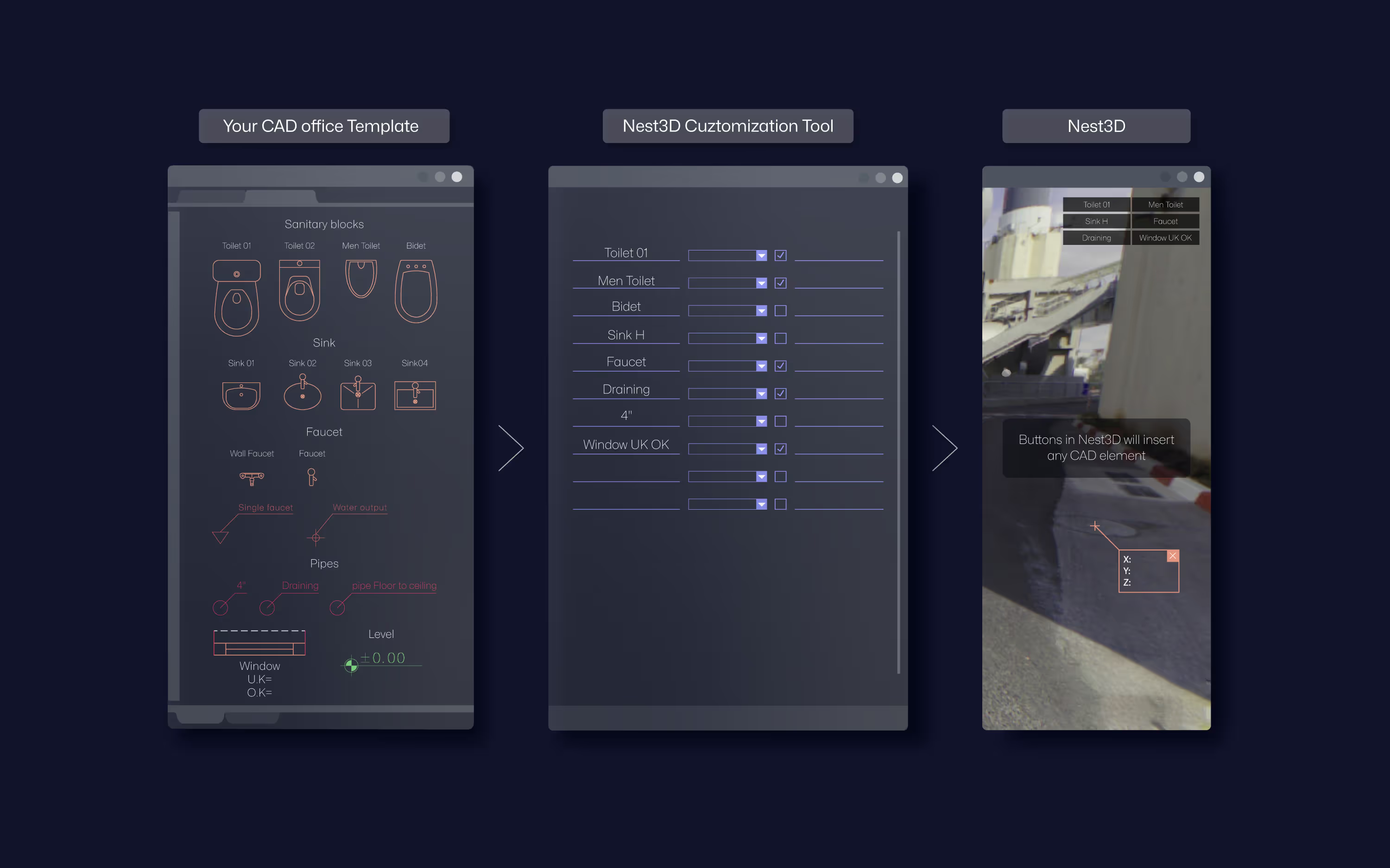
3. Pick features visually in a 360° image workspace.
4. Watch linework stream directly into AutoCAD, BricsCAD, or ZWCAD.
5. Review and QA the final drawing before delivery.
Teams using AI point cloud to CAD tools like Nest3D consistently report up to 60 percent faster drafting, fewer errors, and lower project costs.
By being clear about the software and methods, this step-by-step process shows exactly how to move from raw scans to clean DWG deliverables. It also makes it clear why dedicated software is now the standard for efficient CAD from point clouds.
Point Cloud Software Options
Not all tools that work with point clouds are designed to create CAD deliverables. Some are built for visualization, others for cleaning and registration, and only a few are optimized for drafting. Understanding the differences helps you choose the right software for your point cloud to CAD workflow.
Point Cloud Viewers
These tools allow you to open and explore raw scans. Popular free or low-cost options include Leica TruView and Autodesk’s ReCap Viewer.
- ✅ Useful for visual inspection and client presentations
- ❌ Cannot generate CAD deliverables
- ❌ Limited editing or measurement functionality
Processing and Modeling Tools
Programs such as Autodesk ReCap Pro or CloudCompare are used to clean, align, and register point clouds. They are excellent for preparing scan data but not for generating CAD drawings.
- ✅ Handle large datasets and registration
- ✅ Good for segmenting or classifying scans
- ❌ Do not streamline 2D DWG production
- ❌ Often require exporting to other platforms for drafting
CAD Integration Plugins
Some CAD tools offer plugins that provide limited point cloud support. For example, you can use AutoCAD, BricsCAD, or ZWCAD plugins to import and slice point clouds.
- ✅ Keep everything inside familiar CAD environments
- ✅ Provide basic measurement and sectioning
- ❌ Still require manual redrawing of linework
- ❌ Limited automation for creating final deliverables
Dedicated Point Cloud to CAD Software
The most effective solution is software built specifically for scan-to-CAD conversion. Tools like Nest3D automate the creation of linework, blocks, and text directly inside CAD tools.
- ✅ Works seamlessly with AutoCAD, BricsCAD, and ZWCAD
- ✅ Applies your DWG templates automatically
- ✅ Extracts features visually in a 360° workspace
- ✅ Delivers clean DWG drawings in a fraction of the time
With dedicated AI point cloud to CAD software, surveyors consistently cut drafting time by 60 percent and reduce outsourcing costs by half.
By comparing these categories, it becomes clear that while viewers and processing tools are useful for setup, and plugins offer basic functionality, only dedicated point cloud to CAD software delivers the accuracy, speed, and ROI that modern survey teams need.
Best Practices for Reliable Deliverables
Even with the right point cloud to CAD workflow, the quality of your DWG drawings depends on how you set up and manage the process. Surveyors and CAD teams that follow proven best practices consistently deliver drawings that are accurate, consistent, and easy for clients to use.
1. Start With Clean DWG Templates
Always work with standardized templates that include layers, linetypes, and blocks. This ensures that every drawing follows your company’s conventions and avoids inconsistencies between projects.
2. Break Large Projects Into Sections
Very large point clouds can overwhelm both software and hardware. Splitting the project into logical sections such as floors, wings, or zones keeps performance smooth and makes QA easier.
3. Assign QA to Senior Staff
Junior team members can handle production with modern tools, but senior surveyors should always lead quality assurance. This prevents costly errors from slipping into deliverables and ensures final drawings match professional standards.
4. Keep Scans at Full Precision
Avoid unnecessary downsampling unless file size becomes a technical barrier. Full-precision scans give you the best chance of capturing details accurately in your CAD drawings.
5. Document Your Workflow
Create internal standards for scan import, template application, and QA. A written workflow makes it easier to onboard new team members and maintain consistency across projects.
By following these best practices, survey teams can avoid rework, reduce project risk, and deliver CAD from point clouds that clients trust. Reliable deliverables also build your reputation, making it easier to win repeat business and larger contracts.
ROI of Automating Point Cloud to CAD
The shift from manual or outsourced conversion to automated software is not just about convenience. It delivers a measurable return on investment for survey firms and CAD teams that need to stay competitive.
1. Save 60 Percent of Drafting Time
Survey teams that adopt AI point cloud to CAD solutions report completing drawings in less than half the time compared to manual tracing. A project that once required a week of drafting can often be finished in two to three days.
2. Cut Project Costs by 50 Percent
Outsourcing may remove the burden of manual tracing, but the cost quickly adds up. Automated conversion reduces or eliminates outsourcing, which lowers project budgets significantly. Those savings can then be reinvested into equipment, training, or scaling operations.
3. Improve Accuracy and Consistency
Manual tracing often introduces small but critical errors. Automation ensures that linework follows the scan data precisely and applies your CAD templates automatically. Consistent drawings mean fewer revisions, less rework, and more reliable deliverables for clients.
4. Scale Without Adding Staff
Hiring and training new drafters is slow and expensive. Automated workflows allow existing teams to handle more projects at the same time. Junior staff can take on production work while senior specialists focus on quality control and client management.
5. Build a Competitive Advantage
Delivering faster and more accurate results is a key differentiator in a competitive market. Firms that can produce high-quality CAD drawings quickly not only win more projects but also strengthen long-term client relationships.
In real-world terms, survey firms using Nest3D and other automated solutions consistently report 60 percent faster drafting, 50 percent lower costs, and improved accuracy across their deliverables. The ROI is clear: automation turns scan-to-CAD from a bottleneck into a growth driver.
Nest3D: Proven Point Cloud to CAD Software, Free to Try
Most survey teams struggle with manual tracing or expensive outsourcing. Nest3D is built to fix that. It runs inside AutoCAD, BricsCAD, and ZWCAD, turning raw scans into ready-to-edit DWG drawings in minutes.
- Import scans in E57 or FLS format
- Pick features in a 360° image workspace
- Apply your DWG templates automatically
- Get consistent, accurate drawings up to 60% faster
Surveyors worldwide trust Nest3D to cut costs, save time, and deliver reliable CAD results.
FAQs About Scan to CAD Automation
Conclusion: Faster, Accurate, and Profitable CAD From Point Clouds
Converting point clouds to CAD has always been one of the biggest bottlenecks in surveying and drafting. Manual tracing is slow, outsourcing is costly, and generic tools are not built for reliable DWG deliverables.
With modern point cloud to CAD software, surveyors can finally move past those challenges. Automated workflows cut drafting time by up to 60 percent, reduce outsourcing costs by half, and deliver clean, consistent drawings that clients can trust.
Nest3D makes this possible inside the CAD tools you already use. It integrates directly with AutoCAD, BricsCAD, and ZWCAD, applies your templates automatically, and produces accurate drawings in minutes instead of days.
Turn Point Clouds into CAD in Seconds
Cut drafting time by 60 percent and deliver accurate DWG drawings without manual tracing. Try Nest3D free for 14 days with no credit card required.
Get Started for Free
.svg)


.svg)
