

.webp)
Introduction: Why Surveyors Use 3D Survey Scanners
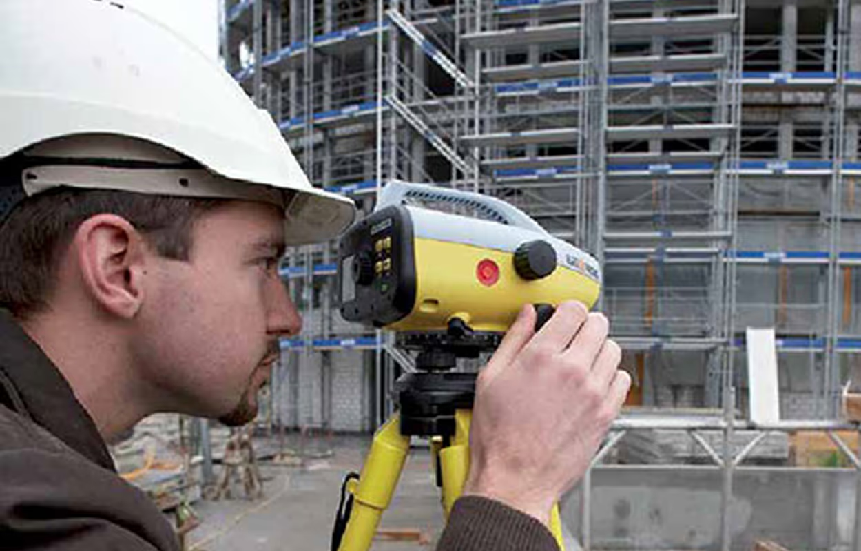
Surveying has always been about accuracy, but traditional methods like tape, total stations, or manual CAD drafting often leave gaps that lead to rework, delays, and client disputes. A 3D survey scanner changes this by capturing millions of measured points across a site in minutes, creating a precise digital record that can be converted into CAD deliverables.
With the right scanner, surveyors can move directly from site capture to usable outputs such as as-built DWGs, topographic surveys, and elevations. This saves time, improves accuracy, and reduces the risk of missed details.
Unlike generic 3D scanners, a survey scanner is built for professional workflows. It exports in neutral formats like E57 or FLS, ensuring smooth integration with CAD platforms such as AutoCAD, BricsCAD, or ZWCAD. The result is faster documentation, fewer revisits, and more reliable drawings for clients.
If you are new to this space, start with our 3D Scanner CAD guide for a broad overview. In this article, we will focus on the role of 3D survey scanners, the workflows they enable, and how they help surveyors deliver projects more efficiently.
What Is a 3D Survey Scanner?
A 3D survey scanner is a device that captures millions of precise measurements across a site and assembles them into a dense point cloud. This digital dataset represents every wall, floor, contour, and elevation in three dimensions, giving surveyors a complete record of existing conditions.
Unlike consumer-grade 3D scanners, survey scanners are designed for professional workflows where millimeter accuracy and scale matter. The captured data is typically exported in E57 or FLS formats, which are widely supported in the industry and integrate directly with CAD platforms such as AutoCAD, BricsCAD, and ZWCAD.
The power of a survey scanner comes from what happens next: the raw point cloud is processed in a scan to CAD for surveyors workflow, where features like walls, levels, and elevations are extracted and written into DWG drawings. This eliminates the need for time-consuming manual measurements and tracing.
Surveyors use these scanners to:
- Capture as-built conditions with millimeter accuracy.
- Produce survey as-built DWG files for architects, engineers, and contractors.
- Reduce the time spent on site while improving data reliability.
- Ensure records are consistent and defensible for compliance.
In short, a 3D survey scanner bridges the gap between fieldwork and CAD deliverables, giving surveyors the tools to deliver accurate drawings faster and with more confidence.
Core Survey Applications of 3D Scanners
A 3D survey scanner transforms how surveyors deliver projects by reducing uncertainty and capturing complete site conditions. Instead of relying on partial measurements or outdated drawings, surveyors can scan once and extract everything they need for CAD deliverables.
Here are the most common applications:
As-Built Surveys
Scanners capture a full site in minutes, producing as-built DWG files that reflect the true state of the building or land. This eliminates disputes with clients and ensures that architects and engineers work from verified conditions.
Topographic Surveys
Dense point clouds can be converted into terrain models and contour lines with precision. Surveyors no longer risk missing elevation changes, making 3D scanners ideal for planning and civil engineering projects.
Boundary and Control Surveys
By tying scans to control points, surveyors ensure that CAD outputs align with site coordinates and legal boundaries. This makes survey deliverables more reliable for both compliance and engineering work.
Construction Support
3D survey scanners help track conditions before, during, and after construction. They can verify progress, confirm that new work aligns with design intent, and reduce costly rework. For deeper construction-specific workflows, see our 3D Scanner Construction guide.
Why Surveyors Benefit from Scan-to-CAD Automation
Surveyors are trusted for precision, but clients now expect results delivered faster than ever. A 3D survey scanner combined with scan-to-CAD automation provides both speed and accuracy, giving survey firms a clear business advantage.
Faster Turnaround
Traditional drafting can take days. With scan-to-CAD software, features such as walls, openings, and levels are extracted directly inside the panorama and written to CAD instantly. Surveyors regularly cut documentation time by up to 60 percent.
More Projects, Same Resources
By delegating extractions to junior staff while senior surveyors handle QA, firms expand capacity without adding headcount. This increases project throughput and revenue per surveyor.
Reduced Site Revisits
One comprehensive scan captures everything. If a dimension was overlooked, surveyors can extract it later from the point cloud, eliminating costly repeat trips.
Consistency Across Deliverables
Scan-to-CAD workflows ensure that every drawing follows the same office standards for layers, blocks, and text. This consistency reduces errors and builds client trust.
Stronger ROI
Even though professional survey scanners are a significant investment, the payoff is rapid. Saving just 4–5 hours per project at an average rate of $80 per hour translates into hundreds of dollars saved per job. Across dozens of projects per year, the scanner pays for itself quickly.
Best Types of 3D Survey Scanners
Not every scanner is equally effective for survey projects. The right choice depends on accuracy, speed, and how data integrates into CAD workflows. Below are the main types of 3D survey scanners, with their strengths and limitations.
1. Terrestrial Laser Scanners (Tripod-Based)
- ✅ Pros:
- Delivers millimeter-level accuracy across building interiors, exteriors, and open sites.
- Produces dense point clouds ideal for topographic surveys and detailed floor plans.
- Best for survey as-built DWG documentation where compliance and precision are critical.
- ⚠️ Cons:
- Slower setup and capture compared to mobile units.
- Higher upfront cost.
2. Mobile SLAM Scanners (Handheld or Backpack Units)
- ✅ Pros:
- Fast coverage of large or complex interiors.
- Ideal for walkthroughs, tunnels, and construction progress checks.
- Lightweight and mobile, reducing time on-site.
- ⚠️ Cons:
- Slightly lower accuracy than tripod-based scanners.
- Works best for projects where speed outweighs millimeter precision.
3. Hybrid Survey Stations with Scanning Capability
- ✅ Pros:
- Combine traditional total station control with 3D laser scanning.
- Tie scans directly to site grids or local coordinate systems.
- Balanced workflow for surveyors who need both georeferenced control and point cloud detail.
- ⚠️ Cons:
- Not as fast as SLAM or as dense as full terrestrial scans.
- Better suited for mixed survey and construction environments.
Where Automation Fits: Turning Survey Scans Into CAD Faster
One of the biggest pain points in surveying is the time lost to manual tracing. Redrawing walls, elevations, and levels from point clouds is slow, costly, and prone to errors.
Automation changes that. With scan-to-CAD software, features such as walls, doors, or contour points can be extracted directly into DWG on the correct layers. This eliminates repetitive redrawing and ensures that outputs follow CAD standards from the start.
For survey teams, this means junior staff can handle the extraction while senior surveyors focus on quality checks. In practice, this division of work cuts drafting time by up to 60 percent compared to traditional methods.
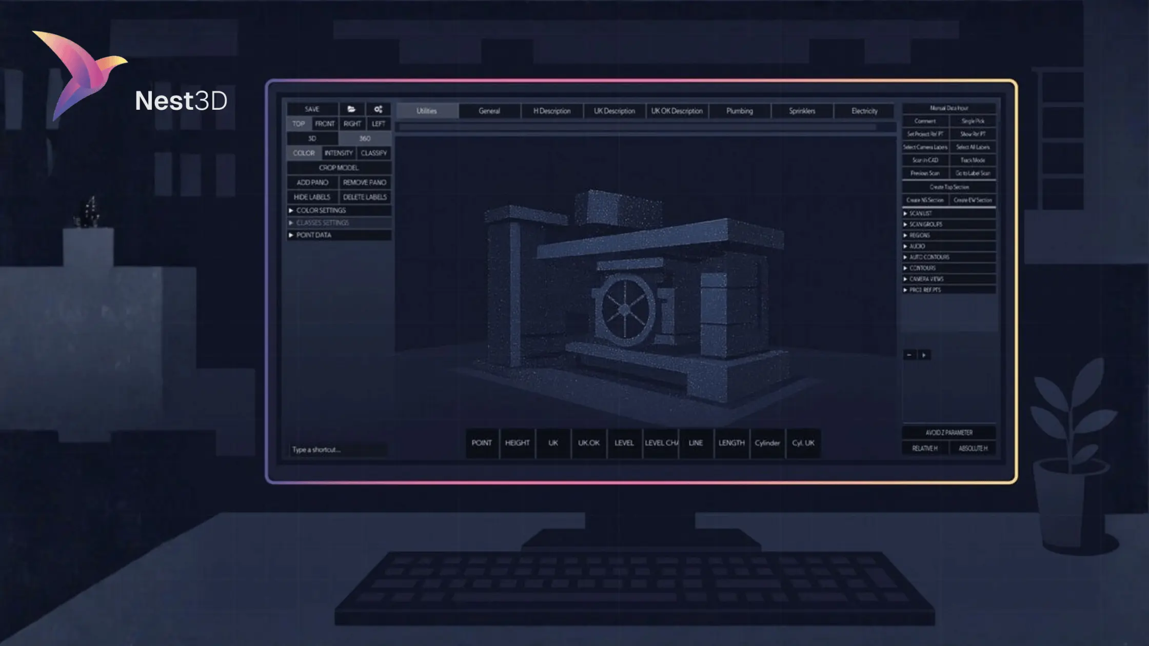
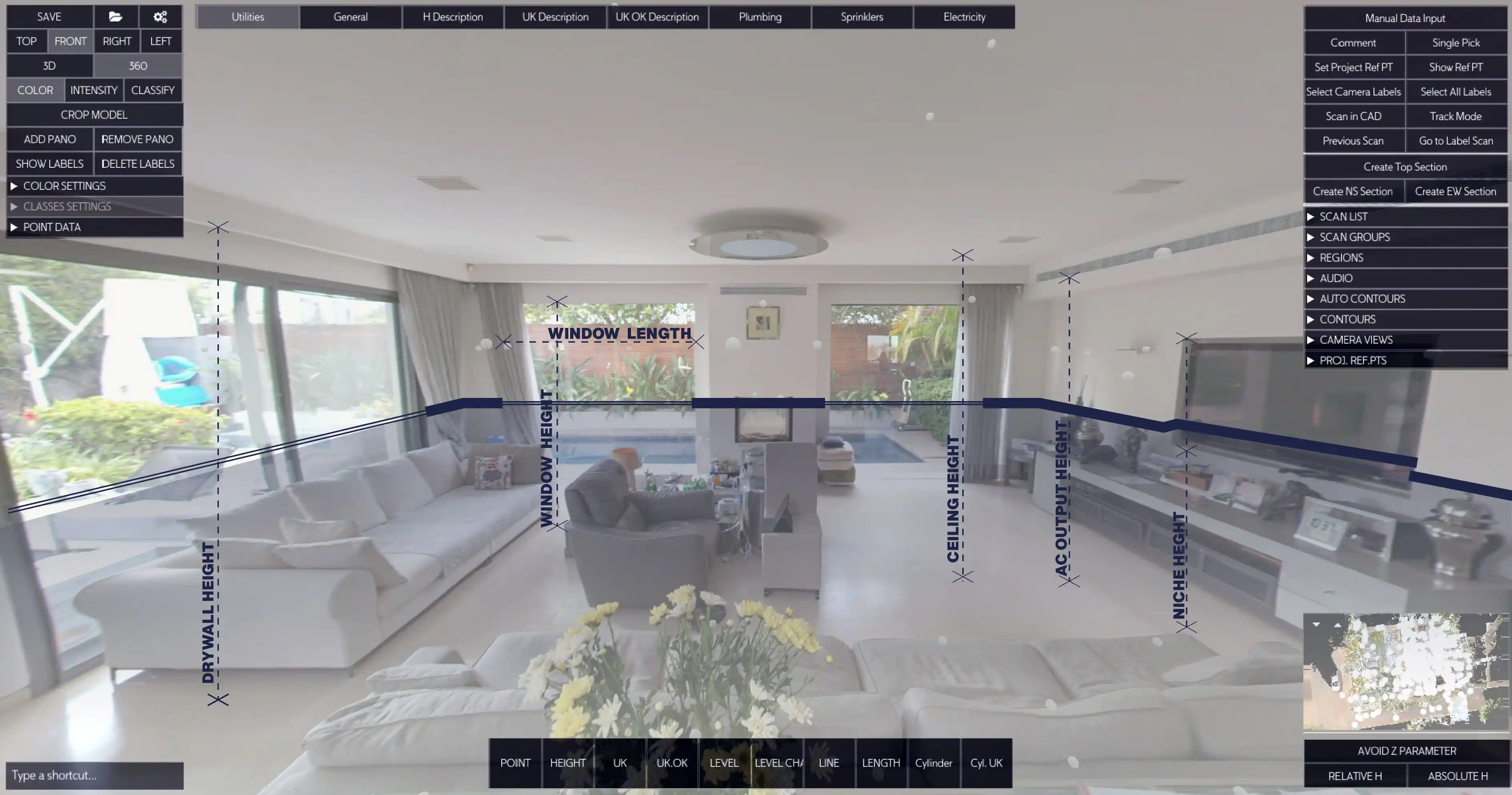
Nest3D plays a key role in this shift by streamlining the survey-to-CAD pipeline. It bridges the gap between raw point clouds and client-ready CAD deliverables, giving surveyors a faster, more scalable way to deliver accurate as-builts.
Automated Survey Scan to CAD Workflow (Step by Step)
The value of a 3D survey scanner is not just in capturing point clouds but in converting them into CAD deliverables that clients can immediately use. A structured workflow ensures accuracy, consistency, and faster turnaround.
1. Capture the Site
- Set up a terrestrial scanner, mobile SLAM unit, or hybrid survey station.
- Plan coverage so walls, elevations, and features are visible from multiple angles.
- Record control points or local coordinates for accurate alignment.
2. Export in Neutral Formats
- Save scans as E57 or FLS files for maximum compatibility.
- Neutral formats prevent errors and keep CAD integration smooth.
- Proprietary formats often add extra conversion steps.
3. Convert Point Cloud to CAD
- Open the scan in scan to CAD software such as Nest3D.
- Click walls, doors, elevations, or survey points directly inside the panorama view.
- Geometry appears instantly in DWG on the correct CAD layers with no manual re tracing.
4. Produce As Built Drawings
- Generate floor plans, sections, elevations, or topographic surveys directly from the scan.
- Deliverables reflect real world conditions with survey grade precision.
- CAD files are client ready and can be shared with architects, engineers, or contractors.
Choosing the Right 3D Survey Scanner
Not every scanner is equally effective for surveying. The right choice depends on the type of project, the level of accuracy required, and how you plan to use the data in CAD. Below are the main scanner categories surveyors rely on:
Terrestrial Laser Scanners (Tripod-Based)
- Deliver millimeter-accurate point clouds across buildings, exteriors, and open sites.
- Ideal for topographic surveys, detailed floor plans, and heritage documentation.
- Best when precision and compliance are top priorities.
Mobile SLAM Scanners (Handheld or Backpack Units)
- Capture large areas quickly by walking through the site.
- Useful for interiors, tunnels, and environments where speed matters more than ultra-dense precision.
- Great for rapid as-built surveys when deadlines are tight.
Hybrid Survey Stations with Scanning Capabilities
- Combine traditional total station control with 3D scanning.
- Allow surveyors to tie scans directly into project grids and coordinate systems.
- Provide a balance of accuracy and efficiency for mixed survey and construction workflows.
When evaluating scanners, surveyors should ask three key questions:
- Does the scanner export in standard formats like E57 or FLS for smooth CAD integration?
- Can it handle the scale of projects I work on most often?
- Does it fit into a scan to CAD workflow that reduces manual drafting?
The best survey scanner is the one that balances accuracy, speed, and workflow integration, ensuring your deliverables are both reliable and client-ready.
Conclusion: Why 3D Survey Scanners Are Now Essential
Surveying is about precision, but today it is also about speed and efficiency. A 3D survey scanner gives teams the ability to capture complete site data once, then convert it directly into CAD deliverables without days of manual tracing.
By adopting scan-to-CAD automation, surveyors gain faster turnaround times, fewer site revisits, and drawings that meet professional standards on the first export. The result is stronger client confidence, higher profitability, and a competitive edge in the industry.
Turn Point Clouds into CAD in Seconds
Cut drafting time by 60 percent and deliver accurate DWG drawings without manual tracing. Try Nest3D free for 14 days with no credit card required.
Get Started for Free
.svg)


.svg)
